The Finger Lakes: Everything You Want To Know
712.75mi² Seneca Lake is home to many invasive species, including Eurasian watermilfoil, curly-leaf pondweed, bloody-red shrimp, Asian clam, and zebra mussels. Boaters visiting the lake
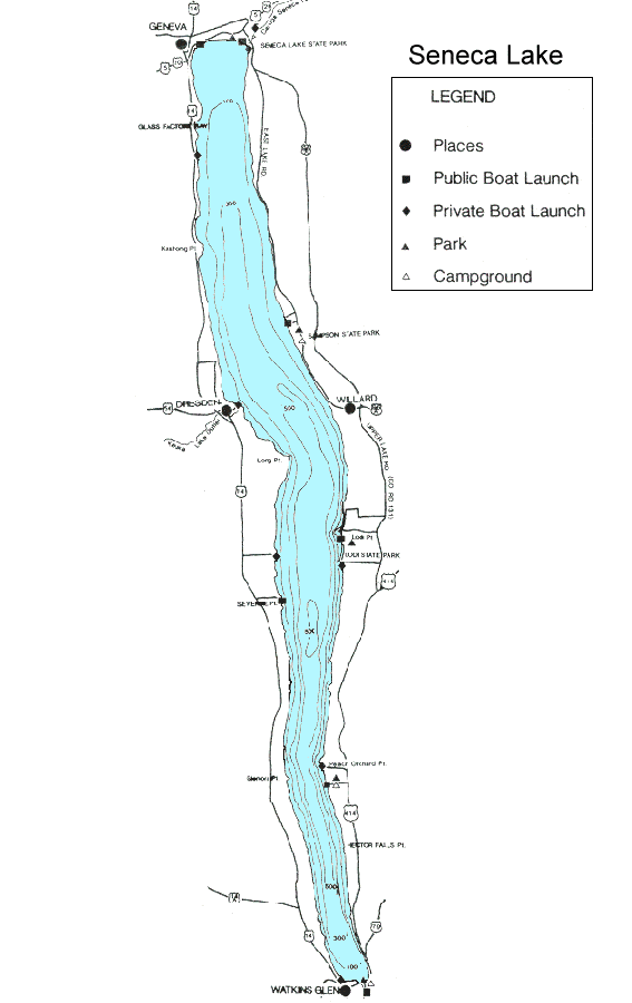
Seneca Lake is one of two Finger Lakes with another flowing into it, Keuka Lake drains into Seneca Lake along its western shore. Seneca Lake is also the deepest of the eleven Finger Lakes and has the largest volume. The great depths and volume of the lake prevent it from completely freezing most years. The lake, as well as those surrounding it, also acts to moderate the local climate, making for perfect conditions for vineyards.
There is plenty to do and explore in the Seneca Lake region, from boating on the lake to visiting world-famous vineyards.
Seneca Lake is home to many invasive species, including Eurasian watermilfoil, curly-leaf pondweed, bloody-red shrimp, Asian clam, and zebra mussels. Boaters visiting the lake should follow clean, drain, and dry your boat before launching and after retrieving to prevent the introduction and spread of invasive species. Some invasive species are difficult to see with the naked eye and can hide among fishing gear, be sure to clean, drain, and dry them as well.
Seneca Lake is classified as mesotrophic, or moderate productivity, and has had harmful algal blooms (HABs) occur on the lake. Residents in the Seneca Lake watershed should take steps to reduce nutrient pollution, which includes maintaining septic systems, reducing the use of fertilizers, and maintaining riparian buffers. Visitors can help too but not disposing of any waste in the lake and being sure to use public restrooms when the need arises.
Land cover in the Seneca Lake watershed. Map created with Model My Watershed.
Open Water
86.92mi²
Perennial Ice/Snow
0.00mi²
Developed, Open Space
38.20mi²
Developed, Low
15.64mi²
Developed, Medium
5.83mi²
Developed, High
1.90mi²
Barren Land
Deciduous Forest
173.38mi²
Evergreen Forest
10.85mi²
Mixed Forest
69.45mi²
Shrub/Scrub
6.78mi²
Grassland/Herbaceous
2.86mi²
Pasture/Hay
107.28mi²
Cultivated Crops
167.34mi²
Woody Wetlands
19.10mi²
Emergent Wetlands
3.75mi²
12.25%
0.00%
5.38%
2.20%
0.82%
0.27%
24.43%
1.53%
9.78%
0.96%
0.40%
15.11%
23.58%
2.69%
0.53%

Stream network and watershed slope in the Seneca Lake watershed. Red areas indicate locations with steep slopes. Map created with Model My Watershed.
1st Order Streams
991.71mi
2nd Order Streams
279.97mi
3rd Order Steams
124.83mi
4th Order Steams
59.08mi
5th Order Streams
47.58mi
6th Order Streams
14.38mi
Length in agricultural areas
252.94mi
Length in non-agricultural areas
1,267.80mi
Total stream length
1,520.74mi
4.57%
2.90%
1.88%
1.03%
0.11%
0.00%
Hydrologic soil groups in the Seneca Lake watershed. Map created with Model My Watershed.
A – High Infiltration
48.68mi²
A/D – High/Very Slow Infiltration
0.00mi²
B – Moderate Infiltration
50.53mi²
B/D – Medium/Very Slow Infiltration
16.91mi²
C – Slow Infiltration
230.82mi²
C/D – Medium/Very Slow Infiltration
131.12mi²
D – Very Slow Infiltration
231.73mi²
6.86%
0.00%
7.12%
2.38%
32.52%
18.47%
32.65%
Lake protection Groups
Water Quality Data & Lake Management


Photo 1: Nicholas Schooley, CC BY-SA 2.0, Photo 2: Mike Procario, CC BY-ND 2.0
Physical Properties
This status does not necessarily represent the current status of HABs in the lake. It indicates whether HABs have ever been reported in the lake.